
A disastrous flood occurred in the historic Fruktova Doukhobor community of west Grand Forks, B.C. on May 11, 1923. The flood resulted from the complete collapse of a concrete dam impounding a small catchment reservoir, now called Saddle Lake, on a hillside overlooking the community. The event was reported a week later in considerable detail in the Grand Forks Evening Sun & Kettle Valley Orchardist newspaper. This web page will revisit that story a full century later, and with reference to newspaper archives and other online sources, it will explore the early origins of the concrete dam and reservoir, its water source from 4th of July Creek, the historic Carson irrigation systems it sustained, and the possible cause of its failure and collapse not long after its construction in 1919.
The "Grand Forks Sun" ...
This was a sensational newspaper story, and it understandably appeared on the front page of the Grand Forks Sun. Originally contained in a single long vertical column, (Link) it has been reformatted here in a more compact readable form. View a text version as a Pdf. (Link)

Photographs depict the Saddle Lake collapse and flood
This newspaper story was not supplemented with maps, drawings or photographs at the time, although photographs did surprising exist. The broken concrete dam and the aftermath of the flood were captured on black and white film by unknown photographers, and at least four of their images have surfaced over time in scattered private collections in Grand Forks. Three of these remarkable photographs are posted below.


Such an unexpected disaster would not be a welcome event at any time or any place. But as we view these historic photographs, it is heart warming to see the collective response of the Fruktova Doukhobor community, both men and women, to quickly remedy the flood damage across the public highway, using sheer manpower and a few horses, without bulldozers, Bobcats or excavators.
A local historian, and former columnist of the Boundary News, personally recalls descriptions of the flood by actual elders. The deluge of water, estimated to be 12 million gallons by some, was said to be sufficiently forceful enough to bring down broken concrete and giant boulders the "size of Volkswagens" through the properties below, further down to the Fruktova lowlands, across the old highway, and down the steep riverbank to the Kettle River. The deep ravine carved into the edge of the bank near the Sion Cemetery is visible to this day and is depicted in this Google street view. And a scattering of large boulders and broken concrete, remains along the ravine all the way down to the riverside, suggesting that this location may have borne the main force of the historic deluge of water.

Photo update - subsequent to the original posting of these historical web page images, a number of additional photographs have been submitted by this same local historian to better visualize the course, and the impact of the disastrous flood.


An extensive web page - for historical context
While the main subject or focus of this web page will be the historic Saddle Lake Doukhobor dam and water works, it will also consider the stories of a number of prominent pre-existing Grande Prairie ranchers and orchardists who occupied the surrounding lands at Carson prior to the arrival of the Doukhobors in 1909. The Saddle Lake page content itself begins here. (Link)
Researching the early history of Carson, July Creek & Saddle Lake
The Carson benchland orchardists
Searching for fruitlands in British Columbia on behalf of the prairie Doukhobors in 1908, Peter V. Verigin, purchased over 4000 acres in west Grand Forks in the following years, the most desirable available lands being on a flat river bench above the Kettle River, then known as the Carson district, just below Spencer Hill. The benchland adopted the name of an old townsite near the American border, envisioned by the McLaren brothers in the late 1890s as a potential border town. The townsite itself was named in memory of their mother, Isabella Carson McLaren, who was said to have looked after their Grande Prairie Hotel. Carson competed for a period of time with the twin cities of Grand Forks and Columbia, and according to The Mining Journal, was even considered a possible smelter site in the late 1890s. But as it turned out, it was not to be the international metropolis envisioned, although it remains an official border crossing and customs office to this day.
An excellent article on the history of Carson by Mildred Roylance, is now available online in the Boundary Historical Society's Report No.11. (Link) Her report featured a detailed description of a John A. Coryell Carson townsite map, although it was not included in her story. Surprisingly a large paper copy of this very map, was recently discovered in a collection of local notary public documents. A large paper map, it was digitized for this web page and for safe keeping, and it has now been donated by the private collector to a local museum. (Winifred Mather Notary Public Collection). (Link) Aside from his work as a surveyor, John Coryell was himself a resident and owner of a ranch at Carson, and his story will be briefly examined in later page segments.


Historian Bill Laux has suggested that there had indeed been consideration of a second alternate smelter, aside from the Granby, to process non-Granby or Phoenix ores, including those from Washington state across the border. But as it is well known, this "Sunshine Valley" managed just fine with only a single smelter, located about a mile or two distant from Grand Forks.

Many later settlers however were less interested in cross-border trade and smelters, than they were in agriculture. They seemingly preferred the flat benchlands just above the Carson townsite, and both Canadians and Americans pre-empted sections and quarter sections in this region, some at Carson where they hoped to cultivate grain fields or fruit orchards, and some at Spencer, for ranches on Fourth of July Creek where they had access to water. (Link) Other settlers had previously begun cultivating the arable lowlands across the Kettle River along the American border in the "Almond Gardens" district.

A workable coexistence of orchardists and ranchers looked promising for a period of time until disputes arose regarding competing interests in water rights to Fourth of July Creek beyond Spencer Hill. Although there were no violent altercations associated with these conflicts of interest, their differences were finally resolved only after a long series of tangled lawsuits and appeals lasting several years between 1902 and 1908, when a ruling was seemingly finally handed down by the Supreme Court of Canada. The details of these entanglements are far beyond the scope of this web page, although in a general sense ... there were only two disputes.
The first, involved the Spencer Hill rancher, Dyer Pettijohn, and the Carson orchardist, William Covert. The latter had been first on the scene, acquiring water rights to Fourth of July Creek in 1894. He had resurrected a pre-existing old miner's water ditch, and then diverted water from the creek, routing his ditch south across the American border, and then back into Canada below Spencer hill, thereby maintaining a continuous down-slope gravity flow waterline to his expansive Carson orchard. Pettijohn subsequently acquired a Crown Grant acreage on this land (now called Sleepy Hollow) near the border in 1898, and also required July Creek water for his ranch. And he applied for his own creek water rights. Covert sued for damages to his water ditch, while Pettijohn suggested that the Covert ditch and water license itself may have been invalid, having crossed the international boundary. Court proceedings subsequently began in 1902 to resolve this matter. (Read source)
Another water rights dispute later arose between Mr. Covert and an adjacent orchardist(s) Vaughan & McInnis. The complicated procurement of water licenses, partly due to the great distances required to acquire them from the Vernon office, the nearest government agency, seemed to be more of an issue rather than the actual details of water diversions and the water works themselves. Both parties also involved respective financial interests. (Read source transcribed)
The following photo-composite depicts the Covert family at left, and the Pettijohn family at right. The Pettijohn story is best told online by the descendants of these settlers themselves in Chapter Three of their excellent family blog. (Link) An excellent detailed look at the Coverts by R. Cunniffe, can also be found online in the 1957 Boundary Historical Society booklet. (Link).

There are no apparent remaining photographs of Vaughan & McInnis, but there is surprisingly a photograph of the home and fruit orchard of the Vaughans.
An early photograph of the Carson Orchards
This may be one of the earliest available photographs of the Carson orchards, taken in 1905 by surveyor John S. Dennis, for a CPR paper on Okanagan and Boundary lands. It depicts what is thought to be a rare view of the Vaughan ranch house in the middle-ground distance, surrounded by the Vaughan & McInnis orchard. The Covert orchard appears in the foreground, extending far right beyond the scope of this image. The same orchard and Covert family residence is also depicted below in a later similar view likely photographed some time after 1912, when the William Blakemore photographer appeared at Carson. By that time, the Covert estate had been subdivided into smaller parcels, and five were purchased by the (CCUB) Doukhobors. Two Doukhobor villages are depicted below in the distance on the former Vaughan/McInnis ranches.
As extensive as they appear to be, it is hard to imagine in retrospect, that the Carson orchards could have all been originally watered by open ditch from July Creek. The first known irrigation pipeline was indeed implemented only after 1905, by William Covert, at great cost. The Grand Forks Sun reported the placement contract ... "Taylor & Fisher, the general contractors, have been awarded the contract for digging the irrigation ditch from Fourth of July Creek to Covert's ranch. The ditch will be 6600 feet in length, of an average depth of three feet, and it will take two weeks to complete the work. The water will have a fall of about 300 feet. Five or six carloads of wooden pipe are expected here soon, and after their arrival, the pipe will be laid in the trench, which will then be re-covered." The completion of the pipeline was understandably celebrated at that time as a "meritorious" achievement. (Link)


The Coryells moved into the Boundary country from the Okanagan in the mid-1890s and their two ranches are also vaguely visible in these photographs in the far distance on a hillside under the shallow opening or low mountain pass. John Coryell was generally preoccupied as a civil engineer and surveyor with offices at Phoenix, Midway and Grand Forks, while his brother Frank, and mother, Margaret, occupied the two Carson ranches. They hired contractors to fence their property, but were not celebrated for cultivating orchards or marketing fruit, and as such had no great need for July Creek irrigation water. And they did afterall partly own "Saddle Lake". But their property interestingly, also had an easily accessible clay pit suitable for manufacturing brick, a resource to be of great importance to the later Doukhobor occupants of their ranch.
The new Great Northern railroad bed also appears vaguely in the photo cutting across the face of what are now known as the Coryell Bluffs, on its uphill course to Phoenix around Spencer hill. The Great Northern, a competitor to the CPR for the transport of Phoenix copper ore to the Granby smelter, completed this railroad branch to Phoenix in late 1904, almost five years after the CPR, partly burdened by the engineering and cost of penetrating these Coryell granite cliffs, troublesome obstacles in its way. The Phoenix Pioneer reported a "work-around" solution to this problem in its 1904 September 10th issue ...
"Thursday morning at six o'clock the largest blast yet fired on this new line was set off on the contract of Martin Weich, a few miles out from Grand Forks. Five hundred barrels of black powder were exploded at once, bringing down thousands of tons of rock on the ranch of Frank Coryell. Preparations for the blast have been going on for some time, tunnels being run in the rock to hold the powder."
A Great Northern (VV&E) ore train was photographed at the bluffs obviously some time later returning empty rail cars uphill from the Grand Forks smelter back to the Phoenix mines for more.

The coincidental completion of the GN railway and the delivery of Covert wooden pipe in 1905 likely by rail, is interesting. Whether the railway delivery was anticipated and planned, awaiting the completion of the railway, or it was simply an unexpected opportunity, is unknown. But it will be argued here, that the GN also played a significant similarly "coincidental" role in the early history of the Doukhobor Saddle Lake dam and reservoir itself.
Spencer and Carson benchland orchards for sale
In the intervening years between 1902 and 1908, the fruit trees of the Carson orchardists continued to mature and the "fruits of their labour", the apples, cherries, plums, peaches, pears, and prunes, were celebrated far and wide across Canada for their quality.
But despite the favourable Kettle Valley climate and the availability of suitable farmlands and nearby markets, the success and good fortunes enjoyed by the Carson orchardists and Spencer ranchers, were not to last. They were burdened by the relentless litigious entanglements over their water rights, and by the various personal challenges facing the orchardists themselves as individuals. What is somewhat surprising, and is perhaps a unique coincidence, that these properties would become available to the Doukhobors, just when they needed them most.
The Pettijohn Spencer settlers, who had been well established in the local community by 1902, had expended their financial resources and were emotionally exhausted after two or three years of confrontation with their Carson neighbours. And they were indeed the first Spencer settlers to sell their quarter sections and leave town. Their ranch was subsequently bought by the Bell family from Colorado in 1902, and the Pettijohns returned to Washington State and the Palouse from whence they had originally come.
While William Covert's orchards prospered, and he seemingly retained his July Creek water right, he was indebted to the Canadian Bank of Commerce and appears to have been forced to subdivide his 320 acre parcel into smaller lots and put them on the market to finance his debt. (Link) And ultimately, according to Harry Barnes, a fellow settler, "the mortgage on his ranch was foreclosed in 1909, and poor Covert lost about all he had." He was an elderly man by that time, his children had married and moved on, and suffering with rheumatism, he and his wife moved into a house downtown, and frequented the west coast and California seeking the healthful benefits of warmer climates.
Vaughan & McInnis also gave up their ranch. Their water rights dispute with the Covert interests would continue for several years, while in the meantime, their orchards were still watered by a small Spencer Hill spring, aside from 4th of July Creek. But there was more on their mind. Leonard Vaughan's ranch house accidentally caught fire in 1903 and burned to the ground, and he was preoccupied with the construction of a new modern residence which was underway a few months later, with a new barn, and stable for thoroughbred horses completed by 1905. And the new home was also spacious enough for a new bride. Mr. and Mrs. Vaughan celebrated a wedding that same year. Dougald McInnis, meanwhile, quietly left town just then and was found wandering about near Vancouver "without sound mind", and although his condition responded to medication, their partnership was essentially over. And by 1909, it was also clear that the Covert court case was not to end well. Mr. and Mrs. Vaughan sold their ranch in March 1910 to the Doukhobors and moved to Chilliwack, where they purchased a small 20 acre ranch. According to the 1911 Canadian census Leonard was living in New Westminster, BC with a spouse and children.
The Coryell story perhaps deserves greater attention, and its own associated web page. But it will be summarized here briefly as it concerns the sale of the Coryell ranches, District Lots 453 and 2651, to Peter Verigin, the first Doukhobor purchases in Grand Forks. The Coryell story is out of character somewhat on this page as they were not generally known as agriculturalists, although their enormous acreage itself was highly praised for that purpose. The name is most often associated with John Abraham Coryell, a professional civil engineer and provincial surveyor, and on reading his 1896 report on Kettle Valley to the BC Surveyor General, (Link) one might get the impression that he was more interested in assessing and measuring land rather than actually occupying it. Although well known locally in the Okanagan and the Boundary country for his work, he is lesser known for his military service and his surveys worldwide. Leaving behind his family in 1900-1901, he left the Boundary "to serve his country" in the South African Boer War, and remained there for many years afterwards surveying railroads and timberlands. He returned to Canada in 1908, and his professional career ended in northern British Columbia, where he contracted tuberculosis while surveying at Fort (Prince) George. Being in no position to maintain his Carson acreage in Grand Forks, he dissolved his partnership with W. Murray in 1909, and began making arrangements with local agents for the sale of his ranch.

Coryell Bros., William (with chain), Frank (with axe) and John (with transit) surveying the photographer's studio.
According to the 1911 Canadian census, John Coryell had been married (to Emma Ferguson Gordon), and the Coryells lived in downtown Grand Forks, on Block 4, Riverside Avenue, were he briefly served as a local government agent. Attempting a recovery from tuberculosis in the warmer climate of Tucson, Arizona, he succumbed to his illness and died there in November 1912. He was predeceased by his father, mother, two sisters and a brother, but was survived by his wife, Emma, and his youngest brother. Frank died at Grand Forks in 1951 and his remains are said to be buried at the Grand Forks Evergreen Cemetery, right next to the Van Ness addition surveyed many years earlier by his brother.
Doukhobors research the British Columbia fruitlands
Fruktovoye, Ubezhishche and Khristovoye ...
Displaced in 1907 from their homestead colonies on the Canadian prairies where they had settled in 1899, (Link) the community-minded pacifist Doukhobors entrusted their leader, Peter V. Verigin, to seek and purchase suitable large tracts of private land for resettlement in British Columbia, where a pledge of allegiance to an earthly crown would not be required. Two community delegates, Simeon Reibin and Nicholas Zebroff, were chosen to accompany him, and they completed the purchase of 2700 acres at Waterloo (Castlegar) on April 14, 1908. This would be the very first of many other such acquisitions in British Columbia to follow. Delegate Reibin however abandoned this initial group, critical of Peter Verigin's judgement and choice of this particular Ootischenia "primeval forest". (Link)
A subsequent search by Peter Verigin for land in the Okanagan and Similkameen in the following winter of 1909 was however unsuccessful, according to the Keremeos Tribune (Feb. 20, 1909). He then returned to Grand Forks, and along with Zebroff and another young associate, John Sherbinin, made an offer on the Coryell Ranch at Carson. Grand Forks newspapers announced that the three negotiated a deal with the McCallum & McArdle agency of west Grand Forks to purchase 900 acres of John Coryell's land for $39,000 in cash that same year, and 160 additional acres of his brother's adjacent lot for "running irrigation ditches". (Link) The same agents, McCallum and McArdle, would facilitate other Doukhobor purchases in the Khristovoye district north-west of Grand Forks.


This western view of the Carson bench depicts what is thought to be Canning Road today. South of the dirt road (left) is likely the Vaughan & McInnis orchard with the Doukhobor Sirotskoye Village in the distance. The Coryell lot is at right. This ranch was Peter Verigin's first purchase in Grand Forks, and the maturity of the Doukhobor orchard here would suggest that the photograph was taken in about 1912, during or after William Blakemore's visit.
The Doukhobor land sales were considered newsworthy local events, and they were routinely announced or reported in the Grand Forks Evening Sun. Aside from the Coryell ranch (DL 453) in the Fruktova Carson district purchased in 1909, the Doukhobors reportedly purchased the Vaughan/McInnis lands (DL. 364 and DL. 365) in March 1910, and five 10 acre parcels from the Covert Estate (DL. 497) at an unspecified but similar date.
At Spencer, they additionally purchased the former Spencer/Macy acreage (DL. 1025) in 1910, the Hoffman acreage (DL. 1737) in 1911, and the former Pettijohn property (DL. 1027) in 1912, (Link) acquisitions largely anticipated as a source of timber and 4th of July Creek irrigation water. And a second fruit-growing region, later called "Khristovoye", was also acquired north east of the Carson bench.
The Fruktova community continued cultivating pre-existing fruit orchards, and purchased additional seedlings to supplement their continued growth, while at the same time, the settlement itself soon blossomed as a vibrant, unified community, and a social and cultural society. Over twenty unique new residential villages were constructed, their multi-family brick faced "doms" in time becoming iconic symbols of the community's prosperity. Its economic growth was sustained by an impressive self-sufficient Fruktova agro-industrial complex, which provided employment for Doukhobor workers, and much needed community income, from the profits of vegetable and fruit production and the commercial marketing of various other non-agricultural products. The CCUB enterprise included a fruit-packing plant/jam factory, machine/blacksmith shop, brick-making plant, and sawmill,
The following map of the Doukhobor settlements in west Grand Forks illustrates their geographical extent in 1938, as well as the three administrative regions designated within them.

The CCUB Fruktova (Fruktovoye) Agro-industrial Complex
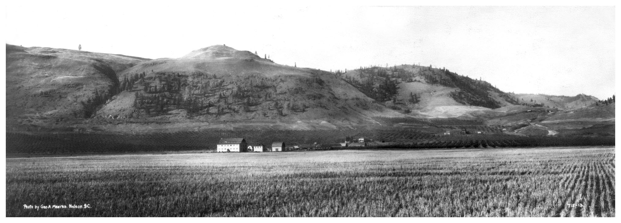
This rare photograph by Nelson photographer George Meeres, was thought to be taken in approximately 1924-1925. It depicts the CCUB Fruktova Agro-Industrial Complex situated on the former Coryell ranch lands. A closer look at the is panoramic image, interestingly reveals what appears to be remaining evidence of the earlier reservoir flood, the scarred hillside at far right, marking the course of the flood water as it found its way downward ravaging the landscape and fruit trees below.

This photograph, likely taken at the same time, is a closer view of the northern portion of the industrial complex. A Doukhobor sawmill is depicted at left, and a blacksmith or machine shop is at far right, this building later temporarily functioning as a community hall. The Gritchin village brick "doms", obscured somewhat by poplars, appear behind, on a flat narrow bench. The Fruktova school will be built here in 1929. Immediately behind the photographer was a clay pit and a brick manufactory, and yet further back, the CCUB fruit-packing house (later jam factory) and granary. These are also depicted in the upper panorama.
"Седлина" (Sedlina), derived from the word "Cедло", a Russian translation for "Saddle"
A shortcut through the shallow pass in the northern hillside above the Gritchin Village, connected Fruktova with the Hardy or Outlook neighbouring community of Khristovoye on the other side. Traversed on dirt road by horse and buggy, the shallow valley indeed resembled the smooth curve of a horse's back where one might place an equestrian saddle, or as in this instance, one may find a small pond or lake. The region at large, including the lake, was thus named "Седлина". Being somewhat swampy at its summit, the pass was not however suitable for expansive orchard cultivation, although the pond or small lake would soon become a source of Fruktova irrigation water..
The Fruktova Water Works
Having purchased the Carson benchland acreages in 1909-1912, and learned from the trials and tribulations of the previous Carson/Spencer settlers, Peter Verigin immediately took steps to acquire July Creek water rights for the Fruktova Doukhobor community. A new ambitious strategy was envisioned to integrate pre-existing water licenses and old works, and extend the old Fourth of July Creek waterlines to Saddle Lake. Although this small lake played no part in the original non-Doukhobor Carson settlements, it could potentially function as a reservoir to hold extra water in reserve for the Fruktova community for its use during the dry summer months.
The details and scope of this strategy were expressed in a number of newspaper water license application notices in 1911, signed by Peter Verigin and notarized by acting Government Agent, John A. Coryell. Three separate licenses were required for access to July Creek water and that of its smaller contributing tributaries. The July Creek application, the most significant here, is depicted at center in the following composite image. The destination of the proposed waterline was to be District Lot 2651 and District Lot 453, the Former Coryell hillside ranches which included Saddle Lake, and interestingly, the water works was proposed to be a "pipeline" and a "small reservoir". Click the notices for an enlargement.

The following diagram illustrates what may be the fulfillment of this plan, an integrated waterline from the Fourth of July Creek to what undoubtedly was Saddle Lake on DL 453. The diagram combines two separate 1913 "conditional" water license maps, simulating a smaller key map included as an inset on the full map (Exhibit A), on page six of license C000259. (Link) Conditional licenses authorize construction of water works, with expected completion dates, and this waterline was to be completed on or before November 1st, 1915. Saddle Lake may have even then functioned as a reservoir, the pond water possibly contained by an earthen berm or dam, although this would at best have been only a temporary measure, as water overflows would have routinely eroded the berm, creating nuisance small breaches and minor springtime floods.

Water License No. C000258 (Link) and Water License No. C000259 (Link)
The water licences further characterized the Spencer portion of the waterline as an "intake and ditch", while the Carson/Coryell portion across Lot 2651 to Saddle Lake on Lot 453, was to consist of an "intake, ditch, and pipe" to an actual "Reservoir". Where the waterline was to transition from an open gravity-fed ditch to a pipeline, is however an open question. The red dotted line depicted here in the diagram is simply the route projected from the Key Map above it. The railroad crossing (likely via culvert under the tracks) however is interesting in that regard, suggesting the possibility that this may indeed have been the transitional point.
With a bit of arm chair engineering and Google Earth, an elevation profile of the waterline beyond the Spence Hill curve was undertaken, and the profile revealed an elevation difference of at least 175 feet, from the crossing below the railroad, to Saddle Lake. Open water is not generally known to flow uphill, and this would suggest that some form of pressurized pipe or siphoning effect would have been required for the final ascent of the waterline to the reservoir.
With such an ambitious water works including a pipeline in mind, it is quite likely that a concrete dam would have also been envisioned as a permanent solution to the shortcomings of an earthen dam. The remaining question may have been only a matter of timing, that is, when it could best be done. Concrete placement itself was not a problem for Doukhobor tradesmen as the procedures had been well tested during the construction of the Brilliant bridge, and the two large concrete reservoirs at Ootischenia. Doukhobor-made wooden stave-pipe was also locally available, being manufactured since 1915 at Kamennoye, across the Kootenay River from Brilliant. The wooden pipes irrigated the expansive Ootischenia orchards and replenished the million gallon Ootischenia concrete reservoir, depicted then and now, in the photo composite below.

Aside from this focus on reservoirs, it is however also
important to point out that there were additional Fruktova water sources, one of which curiously coincides with this GN railroad crossing. A 1913 water license (Link) identifies Vaughan Springs, near this point as a source of domestic water for District Lot 365, with precedence in 1896, undoubtedly originally authorized for the former Vaughan ranch. This water source is relevant to this day, depicted in a Sion Improvement District 1966 water license map. The Vaughan Spring is possibly identified here as North Sion Spring, with an associated water tank and waterline projected toward the current Boundary Museum.

The origins of the Saddle Lake concrete dam
The UBC Library's Open Collections online newspaper archive was a convenient, and indeed an unprecedented welcome source of public information for academic researchers and amateur local historians, when it came on stream in 2010 or 2011. But oddly enough only two newspaper articles referenced the Saddle Lake dam, one about its origins and its possible date of construction, in the Nelson News, and another its collapse in 1923, in the Grand Forks Sun. That story appeared at the top of this page as an introduction to this story. The article in the Nelson News, about the origins of the dam was surprisingly brief, although a great deal can still be learned from it by "reading between the lines".
The "Nelson Daily News" ...
The brief article appeared on page five of the Friday, August 22nd, 1919 issue. A short paragraph in a central column dedicated to news from the Kootenay Boundary, it consisted of only 13 lines and about 70 words. But although brief, it opened the door to further research. The full original news page is here as an image, (Link) and a clipping has been reformatted below for a closer look.

A closer look and fact check ...
While aspects of the single paragraph are informative and would appear to be accurate, others are only somewhat so. The initial reference to the Hardy Bros. ranch is interesting, and it was indeed purchased by the Doukhobors just that year. But the "all-season lake" and "converted immense concrete reservoir" were in reality on the Newby/Coryell-Murray Lot rather than the Hardy Bros. ranch. That detail can perhaps be overlooked, as the Hardy irrigation infrastructure has had a life of its own, and was also extensive and complicated. It has since then evolved considerably, and is now part of the Sion Improvement Irrigation District. (Link)
What is more interesting however is the seemingly trivial little comment in the newspaper clip about the cement delivery on August 20, 1919. As it turns out, this tiny detail opens a pathway of inquiry to finally determine the early origin of the concrete dam.
The Great Northern and Granby Smelter
Readers with an interest in local history would know that this delivery would have involved a Great Northern (VV&E) railroad freight car. And many would also know that 1919 was a very consequential year for the very future existence of this railway, and indeed, for the lasting history of Grand Forks city itself. Affected by the looming closure of the Granby Phoenix mining operations and the Grand Forks smelter, the Spencer to Phoenix branch of the railway line was in jeopardy. Robert D. Turner, the undeniable expert documentarian of Boundary railroad and smelter histories describes the moment on page 164 of Steam Along the Boundary. The relevant content is briefly paraphrased below:
"Granby announced the closure of its Phoenix mining operations on April 9, 1919, and the GN hauled its last car of ore from the mines to Grand Forks on May 12, the last passenger train running on June 13. Dismantling of the complete main Great Northern branch line from Phoenix through July Creek and Spencer to Grand Forks, as well as the smelter branch, began in the autumn of 1919. It was reported in the November 7th Gazette, that two carloads of Doukhobor workers had been brought in from Manitoba, as labourers for the work. In December, work was temporarily suspended for the winter and not resumed until the snows melted from the mountains the next spring. In June, crews continued dismantling the Phoenix line and trains were running daily, hauling out rail and other valuable scrap. This work was completed by mid-August 1920."
Also of note, R. D. Taylor claims that the CCUB Doukhobors had purchased the celebrated Granby Phoenix hotel for salvage, as well as certain remaining GN right-of-ways across their settlement lands. The Great Northern downtown railroad spur to its passenger station however remained in service for about another ten years, to maintain a connection to Spokane. And ironically, this was the station and train route Peter Verigin had pre-arranged for his fateful trip to Oregon from Grand Forks, when he died en route at Farron on October 29, 1924.
The completion of Peter Verigin's Grand Vision ...
The construction of a concrete dam at Saddle Lake of that magnitude would certainly have entailed considerable preliminary planning and preparation, the draining of the lake, the site preparation, and as with all other concrete placement requirements, lumber for forms, steel reinforcements, and of course, skilled labour and at least a rail-car load of cement.
Peter Verigin may have heard rumours of the imminent closure of the smelter, but with the arrival of the carloads of Doukhobor workers from Manitoba in the early spring of 1919 to dismantle the railroad, the reality was more than rumour. It is quite possible that this realization may have hastened what were formerly long-range plans envisioned for the conversion of the lake to a reservoir. This was a narrow window of opportunity to initiate construction, while the railroad itself was still in service to transport the required supplies for the dam, and the wooden stave-pipe for a later proposed waterline.
At the same time, the Great Northern was more than happy to resell its right-of-ways, and the railroad beds could then potentially serve as a route and foundation for a stave-pipe waterline from the Fourth of July Creek to the Saddle Lake reservoir. Surprisingly, this was confirmed in a report written in the early 1960s by authors least expected.
High School Scholars and the July Creek waterline
The placement of the pipeline was briefly described by three Grand Forks High School students in a written report on general Doukhobor history, and its content was sourced directly from well-informed local elders. This report initially appeared in the USCC Doukhobor ISKRA magazine, and it was later reproduced in the 1960 Report Booklet of the Boundary Historical Society. (Link)
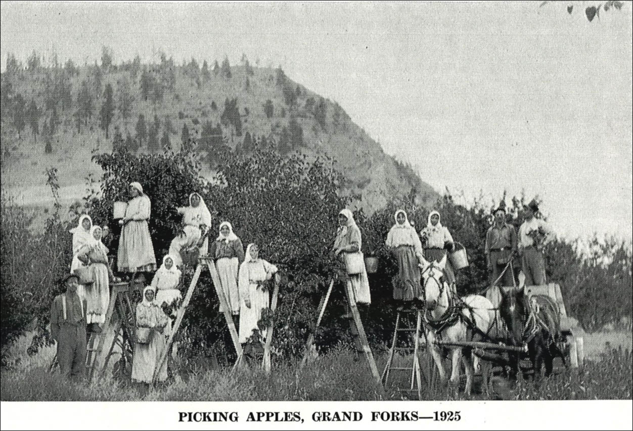
These apple pickers appeared in the report, as did the following relevant paragraph reproduced below, courtesy of Vera (Novokshonoff) Kanigan, one of the original authors.
"In 1909, work was started on building an irrigation pipeline. A trench 2 to 3 feet deep was dug from First [Fourth] of July Creek to Sion following a line above the roadbed of the Great Northern Railway, and pipes were laid extending for about 2 miles to bring water to the newly planted orchards and gardens. A few years later when the Great Northern dismantled the railway track, the pipes were relocated to follow the road bed and enlarged to 6 inches in diameter to carry more water. Later another pipeline was built to supply homes with drinking water, taken from a creek [Vaughan Springs (Link)] running halfway up the mountain at Sion. Water was also piped at the Outlook settlement for drinking as well as for irrigation purposes."
Though brief and with a minor error, the report reveals a number of previously undocumented details about the origin and evolution of Doukhobor irrigation infrastructure. Although Saddle Lake is not referenced in their report, the early route of the pipeline above the GNR tracks is noteworthy, and seems to partially confirm the route of the proposed 1913 pipeline depicted on the water license map. Furthermore, their comment about the dismantling of the GN railroad and the subsequent realignment of the pipeline route is indeed even more significant and to the point. The two later 1926 Final water license diagrams below depict precisely that route after the removal of the tracks, along the old railroad bed. The July Creek diversion was now depicted at the extreme northern boundary of the Hoffman Lot 1737 acreage, and the terminal point of the route approached the southern segment of Saddle Lake. It should be noted that this diagram depicts the waterline after the 1923 collapse of the Saddle Lake dam.

Water License No.5393 (Link) and Water License No.5394 (Link)
Current remaining physical evidence of the July Creek waterline
Despite this rather belaboured research and history of this waterline, its true character and specifications remain undetermined, although if it were felt worthwhile, it could still be done in the real world. Sections of the old rail bed are even now relatively undisturbed and would be open to forensic excavation by modern back-hoes or excavators. In the meantime, the Grand Forks High School reference to the waterline as a 6 inch pipe submerged under 2 or 3 feet of railroad bed, may ironically be the only written description of its actual nature.
A personal research map of Spencer creek waterlines
The main July Creek waterline, and the various waterlines of its smaller tributaries, have been of personal family interest to this writer for a number of years, and I have referenced various archival records, old newspapers, historic water licenses, and their associated maps, in my ongoing research.
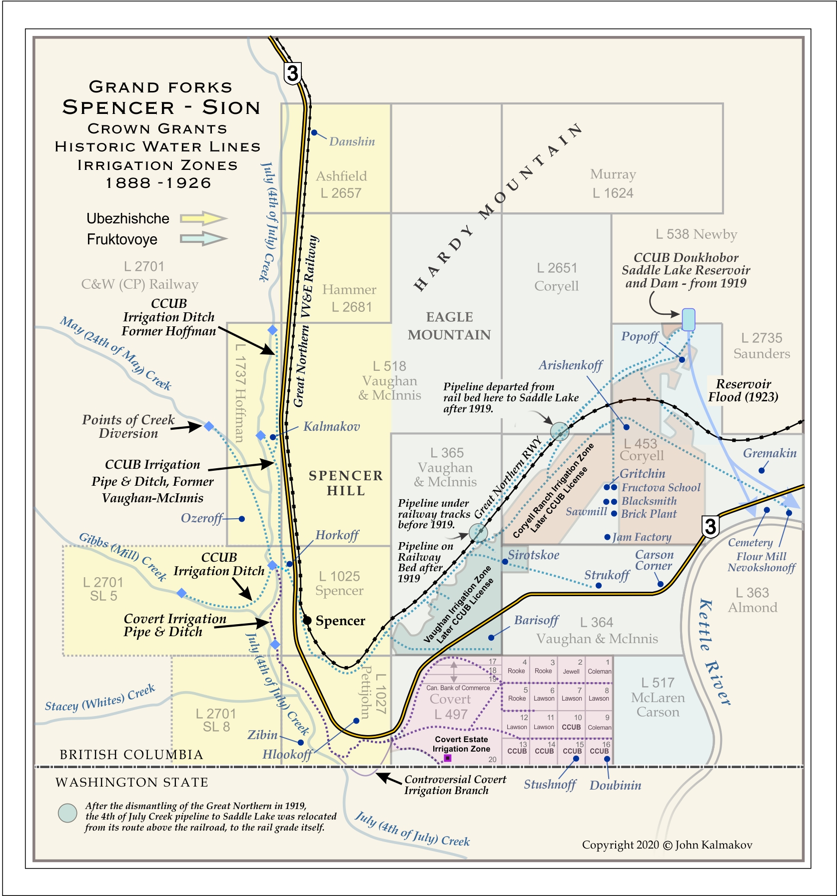
The following composite Spencer-Carson waterline map (Link) is in a sense a summary of my findings. Not by any means presumed to be "scholarly" work, nor a definitive comprehensive map, it is essentially a compilation of multiple historic water license maps. Navigating the BC Water Branch online database was unfortunately somewhat frustrating, as some of the older records, even when found, were incomplete, or their maps seemingly misplaced, perhaps lost in hurried record keeping following the court cases of the early 1900s. The various individual waterlines are not dated, as many of them represent an evolutionary sequence of revisions and renewals. Researchers or curious readers seeking more complete or official current information on water systems in this region of west Grand Forks can of course consult Grand Forks or Sion Improvement District offices directly.
Arm-chair speculation about the collapse of the concrete dam
Another rare photograph, the final of four flood photos, reveals the broken concrete of the old Saddle Lake dam, and the collapsed earthen abutment below it designed to restrain the downward force of the reservoir water. The vertical scale of the structure can be estimated from the size of the human figures seemingly inspecting the damage at photo bottom-centre, near what appears to be a concrete footing.


Seasonal overflows and forensic analysis
The unexpected collapse of the 1919-1920 dam in 1923, so soon after its construction, would understandably raise questions about its structural design and integrity. Concrete itself may have been an issue if it were freshly poured, as there is a known improvement in its strength with continued curing. Exposure to freezing temperatures while curing could also be an issue. And then there is also the question of steel re-enforcement, which appears to have been non-existent.
With recent engineering focus on the erosion of the earthen backing of the modern concrete Saddle Lake dam, there would be good reason to suspect that this form of erosion may have likewise been a problem in the 1920s. In these photos, a section of this backing has remained intact and it appears that the compacted dirt was surfaced with a veneer of mortared rock to strengthen it and prevent its erosion. There is no doubt that it had crumbled, and could the effectiveness of this mortared veneer been over-estimated, as it would seem to be still vulnerable to cracks and fissures opening it to water infiltration?
Springtime Saddle Lake reservoir overflows were also an issue, addressed today by modern civil engineers. Whether precautionary strategies were in place to mitigate this potential threat in 1923, however is unknown.
What is known is the actual measurement of rainfall and snowfall for the spring months of 1923.

As Saddle Lake was west of Grand Forks in the direction of Greenwood, and somewhat higher in altitude, an average of rainfall and snowfall between the two stations wouldn't be unreasonable. In that case the amount of rainfall at Saddle Lake in the month of May in 1923 would have been approximately 100 mm. or 4 inches. And the amount of snowfall since January would have been approximately 56 cm. or 22 inches.
This is rather elementary science, but perhaps sufficient to suggest that this may have been an unseasonably wet spring, with the possibility of excessive reservoir volume and load on the concrete dam, resulting in unusual overflows, and its ultimate collapse.
In the news once again ...
The Saddle Lake dam was presumably completely rebuilt not long after its collapse in 1923, and it served the local Doukhobors and the wider community without apparent serious incident in subsequent years, and it may indeed have been somewhat taken for granted, until recently. The dam became newsworthy once again in 2012 when concerns were raised by professional engineers about its continued safety, with potential great risk for the downstream residential community. And local environmentalists also discovered that the ecosystem of the Saddle Lake reservoir itself was likewise in danger.
For readers unfamiliar with this local rural infrastructure, the dam and reservoir can be accessed by a narrow winding paved road from either the northern side of Grand Forks through the Outlook or Hardy Mountain area near Ward's Lake, or from the southern Carson side a few miles distant west of Grand Forks on Hwy. 3. When driving uphill past the Doukhobor Sion Cemetery, a paved road (Reservoir Road) branches to the right and leads toward Saddle Lake, about a mile past the old Fruitova school, now the Boundary Museum. The route can be previewed online with a Google Street View. Click to view.

About modern Saddle Lake, as a dam and ecosystem
Now under the jurisdiction of the Regional District of Kootenay Boundary (RDKB), the dam is being routinely monitored by professional engineers. A recent report by a civil engineer from Trail, BC, (Link) briefly summarized the character of the dam in the following technical terms:
"Saddle Lake Dam is a concrete faced earth-fill dam and impounds a small reservoir with an unknown water source, which is likely groundwater with some overland flow from the small catchment area. The earth portion of the dam serves as the weighted mass to counteract the upstream pressure from the water, while the concrete serves as the impervious barrier to prevent water from seeping through the dam.
The dam structure is six (6) meters tall and approximately 44 meters wide and impounds the area of water known as Saddle Lake. Saddle Lake is a man-made lake located in the saddle-like depression between Eagle Mountain and a smaller unnamed mountain 6 km west of Grand Forks. It was built by Doukhobors in 1912 as a reservoir dam to meet irrigation needs for the extensive communal orchards and grain fields below."
The engineers observed several troublesome developments, the most significant being evidence of water seepage through the earth-filled downstream abutment of the concrete dam, jeopardizing its continued integrity. The seepage was thought to be caused by reservoir overflows during springtime freshets that penetrated the porous earth abutment, weakening its effectiveness. This concern was mitigated to some extent in 2019, with upgrades to the infrastructure funded by a $190,000 grant from the Federal Gas Tax Fund, implementing a mechanical system of spillways to control reservoir overflows. The work was summarised in a press release by the RDKB, and reported by The Rossland Telegraph. (Link) The BC provincial government also later kicked in almost $400,000 in funds in 2021 for additional measures to safeguard its continued function and maintenance. The funding was announced in The Boundary Sentinel on June 9th, 2021. (Link)
A current clickable Google Street View of the Saddle Lake dam appears below. Of particular interest in this view is the earthen abutment below the dam, and the recently upgraded reservoir overflow spillway specifically recommended earlier by civil engineers.

Tiger Salamanders and the Saddle Lake ecosystem
The Saddle Lake reservoir itself has also been recently newsworthy, albeit for a different and quite unexpected reason. It too was similarly assumed to be quietly managing its own affairs, and the discovery that the biodiversity of its ecosystem was in jeopardy came as a surprise to many. A species of little creatures called Tiger Salamanders was found to be threatened by the inadvertent introduction of domestic goldfish into the pond that were ravaging their metamorphic life, devouring their eggs and young tadpoles or larvae. The Western-Canadian variant of the species is depicted below, characterized by its distinctive tiger-skin. These amphibians are prolific across Canada and North America at large, and their threatened life and times in various loosely regulated environments is well documented online, and indeed worthy of concern to all.

The Saddle Lake concerns were initially expressed by the local non-profit Granby Wilderness Association spearheaded by Jenny Coleshill, who had studied this and other related matters. According to a Grand Forks Gazette article by Craig Lindsay, the Regional District addressed this issue by designating Saddle Lake and its five acre surroundings as a protected Regional Park. (Link) Its intended purpose was twofold, to bring awareness to its ecological value, and to offer local residents recreational opportunities in its natural surroundings, for trail hiking and generally "checking out pond life".